Thursday, October 30, 2008

Cook's Inlet

Sky Watch Friday


Beautiful Summer Day over Cook's Inlet
Anchorage, Alaska, USA
(Click the photo for a full page view)

The famous
Turnagain Arm of Cook Inlet is to the left in the photo.

Turnagain Arm is one of only about 60 bodies of water worldwide to exhibit a tidal bore. The bore may be more than six feet high and travel at 15 miles per hour on high spring tides. Turnagain Arm sees the largest tidal range in United States, with a mean of 30 feet (9.2 m), and the fourth highest in the world, behind Bay of Fundy (11.7m), Ungava Bay (9.75m), and Bristol Channel (9.6m). The ocean's natural 12-hour 25-minute tidal cycle is close to Turnagain Arm's natural resonance frequency, which then reinforces the tide similar to water sloshing in a bathtub. Tidal fluctuations in the main body of Cook Inlet, while not as extreme as the shallow and narrow Turnagain Arm, regularly reach 25 feet (7.6 m) and exhibit currents in excess of 5 knots (9.3 km/h) at full tidal flow. The inlet and its arms have been proposed as a potentially attractive site for the generation of tidal power.

We traveled back and forth along the arm over a dozen times and watched the tidal bore. sometimes the surfers come out and ride the one-time wave as it advances.

For more information on Cook's Inlet (click here).

If you like great 'wide-open spaces' Skies,
Scroll down one post to see some great sky photos from Big Bend National Park.
It will be worth your time.

Leave us a comment here and there.

For other SWF posts,
see Tom's SkyWatch site here
.


Troy and Martha

.

Monday, October 27, 2008

Texas (Our Part of the world) #2


My World Tuesday Part#2

Based in Ft. Worth, Texas

Today's Topic:
Big Bend National Park
(Click on the photos for full page views)

Big Bend National Park encompasses more than 800,000 acres in southwest Texas. For more than 1,000 miles, the Rio Grande forms the international boundary between Mexico and the United States; Big Bend National Park administers approximately one-quarter of that boundary. Within the 118 twisting miles that also define the park’s southern boundary, the river’s southeasterly flow changes abruptly to the northeast and forms the “big bend” of the Rio Grande.


Looking toward Big Bend
Shot from nearby Big Bend Ranch State Park

Big Bend Ranch State Park, the largest state park in Texas, covers 300,000 acres of Chihuahuan Desert wilderness in a remarkably rugged, remote and unpopulated setting. The park extends along the Rio Grande from southeast of Presidio to near Lajitas in both Brewster and Presidio Counties. Embracing some of the most remote and rugged terrain in the Southwest, it encompasses two mountain ranges containing ancient extinct volcanoes, precipitous canyons, and waterfalls. The area has been a crossroads of human activities for over 11,000 years, as diverse people and cultures have been drawn by the abundant resources of the Rio Grande/Rio Bravo corridor.


Rare Early Morning Mist
photo 30 min after Sunrise
Click to enlarge Panorama


Camelback hills
Landscape 1


There is a lot of green here
Landscape 2
toward Marathon


Prairie Verbena
Growing out of a rock face


Ocotillo
near Panther Junction


One of our Favorite areas in the Summer is the Basin. It is a bowl in the Chisos Mtns. The temperature mid-day will be 85 oF. up in the basin and 115 oF. down on the alkali flats. There is a great lodge and some individual cabins in the Basin as well as lots of campsites. The Restaurant at the Lodge is outstanding.

Here are a couple of photos taken after sundown in the Basin. If you look at the topographical map (scroll down), you will see Casa Grande mountain rising above the basin to the south-southeast. The first photo is a time-exposure taken of Casa Grande. The second time-exposure photo is taken much later after dusk, with only a faint glow in the sky. If you look at the map, you will see a notch (named the Window) in the Basin to the west for the water drainage. The Window is perfectly positioned for the sun to set in this notch. It is a popular pastime to take a short hike to a high point in the Basin and watch the sun set. It is a fantastic view and you can see the flats through the Window. It is possible to drive around and down and then hike to the base of the cliffs at the notch. There is almost always water falling from above into small pools here. If you are lucky you can hear Canyon Wrens calling. Big Bend is a great place to find some rare birds.


Casa Grande
Illuminated by twilight


West Texas Silhouette
The "Star" is Venus


After Sunset
Through the Window.
About 30 min after sunset


Topographic Map of the Basin Area of
Big Bend National Park


The National Park System in Texas is here.


Did You Know?
According to legend, a lost Spanish mine is located in the Chisos Mountains. The Conquistadors used the Presidio de San Vicente as a prison and from there worked a mine in the area. The guards blindfolded the captive Indians and marched them from the Presidio to the mine, supposedly in the Chisos.


We hope you have enjoyed our small start of explaining and showing our small part of the world, and we look forward to your return. We sincerely hope you will bookmark us and return often.

Update: I forgot to ask, what is your favorite photo?
Leave a comment. Thanks.

Photography by
Troy and Martha


Please visit "That's my World" for other great places of the Earth.


.

Sunday, October 26, 2008

Alaska Sunday XXIX

.
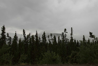
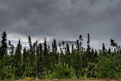
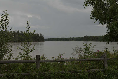
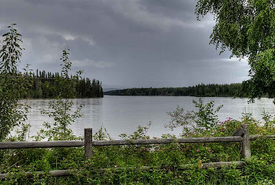
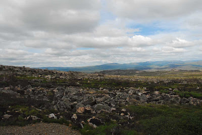
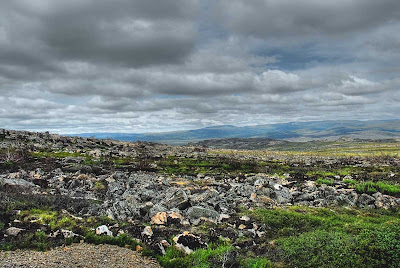
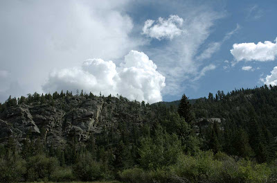
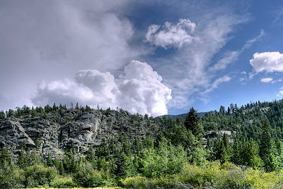
Uses for HDR Photography

All photos are from Alaska

(Remember to click on the photo for a full page view)

Many times when making a photograph, we shoot a photo +/- one stop (or more) to be sure we get a reasonably close approximation for the correct exposure. We then select the one that more closely approximates what the mind remembers, that which the eye saw. In a way, this is a type of manipulation of the photograph. A secondary software manipulation could be (a) sharpening a slightly out-of-focus photo, (b) adjusting the endpoints of white and black to produce purer whites and blacks (levels), (c) increasing the saturation on a cloudy day to increase the level of color intensity to a remembered level, (d) etc., etc.

Occasionally we make a photo of something that has a dynamic range of light to dark that the camera is not capable of capturing in one photo. The eye may be perfectly satisfied with what it saw and a picture is burned into the mind. We view the produced photo and say, "this is not what I saw or remember". Enter the fairly new software, HDR (high dynamic range) manipulation.

There are a lot pf web sites which discuss the use of HDR which was initially developed for the purpose of taking 3 or more exposures and combining them to produce one photo. i.e. expose for the sky, expose for the mid-tones, expose for the shadows.

For the intent of this demonstration, I am only concerned with taking a single frame photo (which may be unusable or just not what I expected or remember) and turning it into a photo which more closely approximates what I remember. It may not be perfect, but is acceptable for a photo album, a trip reminder, a special scene or occasion.

Please leave a comment and your thoughts. I am really interested.

Following are 4 examples of such photos.
What would you have done to the original?
Remember, the final or manipulated photo can't be compared to a photograph taken in good lighting conditions with a normal dynamic range and in most cases won't resemble one.


Fog


Original

Corrected in order to
increase sky contrast and see detail in the foreground,


Misting Rain

Original

Corrected in order to increase contrast.
I did lose some of the effect of impending rain,
but gained color and detail in the fence row.
(I will probably go back and work on a compromise for this).


Finger Mountain Area
North of the Arctic circle


Original

Corrected in order to
decrease the dynamic range and
bring out the color and texture of these beautiful rocks


Clouds Rising


Original
(An acceptable photo to emphasize the sky)


Corrected in order to
bring out detail and color in the foreground and cliffs.
It also shows the side lighting.


All of the photos are of scenes which had some special interest to us,
rather than just capturing a nice photograph


Photos by Troy and Martha
HDR Processing by Troy
Final exposure negotiated between Troy and Martha

.


Thursday, October 23, 2008

Backpacking in the Rain

Sky Watching for Sure

Backpacking in the Rain
Rocky Mountains, Colorado, USA

Get out the Rain Gear !
Lightning ?
Let's get over at the base of those cliffs !
I love the sound of thunder rolling down the canyons !

(Click on the photo for a full page view of the coming rain).


Be prepared for the unexpected.
A flat meadow with a nearby stream,
It will make a great campsite !


Have you ever been caught by unexpected weather while backpacking or just a day hike?

Leave us a comment.

For other SWF posts,
see Tom's SkyWatch site here
.


Troy and Martha

.

Monday, October 20, 2008

Texas (Our Part of the world)

.
My World Tuesday #1

Based in Ft. Worth, Texas


Today's Topic:
Where the Buffalo Roam and the Antelope Play
(Click on the photos for a full page view)


Plains Bison on the Prairie
5000 acre refuge of restored grasslands
Near Ft. Worth, "Where the West Begins"
Photo by Troy


Antelope Not at Play
Early Summer Morning Snack, Before the Heat of the Day
High Plains of West Texas

Photo by Martha


Over the coming months we will try to inform you of the many facets of our state,
from geography and geology to natural history,
with a special emphasis on photography of our state.

Please leave comments and tell us if you enjoy the post today,
and tell us if there is anything special you would like to see in the future.


Today: A few facts about Texas

Capital: Austin
Government: Bicameral Legislature
28th State to enter the Union:
Dec. 29, 1845
Present Constitution adopted: 1876

State motto: Friendship

Origin of name: Texas, or Tejas, was the Spanish pronunciation of a Caddo Indian word meaning "friends" or "allies."

Nickname: Texas is called the Lone Star State because of the design of the state flag: a broad vertical blue stripe at left centered by a single white star, and at right, horizontal bars of white (top) and red.


Population (Jan. 2006, State Data Center estimate) 23,507,783
Number of counties: 254
Number of incorporated cities: 1,208

The Natural Environment

Area (total): 268,581 sq. miles
Land area: 261,797 sq. miles
Water area: 6,784 sq. miles
Geographic center: About 15 miles northeast of Brady in northern McCulloch County.
Highest point: Guadalupe Peak (8,749 ft.) in Culberson County in far West Texas.
Lowest point: Gulf of Mexico (sea level).

For more information about the Natural Environment of Texas, Click here.


We hope you have enjoyed our small start of explaining and showing our small part of the world, and we look forward to your return. We sincerely hope you will bookmark us and return often.


Troy and Martha

Please visit "That's my World" for other great places of the Earth.


.

Sunday, October 19, 2008

Alaska Sunday XXVIII

Four-wheel Drive Day

Hope, Alaska
July 17

While we were using Anchorage as a base camp, we decided one day to drive around to Hope, AK for a day of birding and photography. Hope is situated on the southern side of Turnagain Arm off of the Cook Inlet. It is about a 2-3 hour drive to Hope from Anchorage. It is a beautiful drive through the Chugach National Forest on the West side of the Chugach Mountains. Lots of wildlife, from Squirrels to Moose to Thin-horn Sheep.

We had read of a great 4-wheel drive road South out of Hope up Palmer Creek Road and Resurrection Creek Road. We spent a couple of hours on the Palmer Creek road and then returned to Hope for lunch at a little Mom and Pop Diner. Great food.

We then returned to the Resurrection Creek Road and started up the valley. Up near the treeline we hoped to find some Golden-crowned Sparrows. We found beautiful meadows lush with wildflowers, grasses, and amazing vegetation. Eventually we encountered a sign "4-Wheel Drive Only." Of course, we proceeded on around the sign. The next sign said something like "Turn Around Here, Road Impassable". Of course we drove around it and proceeded. Much of the road was overgrown with small brush, and we did get some scratches in the Clear coat and Paint (about 8 hours work with the buffer, scratch remover, and polish when we got back to Texas). We saw some beautiful scenery and best of all, we found the summer breeding ground of the Golden-crowned Sparrow. In all of our years, we had only seen one other Golden-crowned Sparrow migrating through West Texas.

Following are a few photos along the way.

Be sure to click on the photos for a full page view.


Lower altitude Meadow


Higher altitude


Cold (really cold) Mountain Stream
It felt colder than the Arctic Ocean that we waded in


Mountain Valley
Still lots of snow up here


Getting near Resurrection Pass


Most of the photos have been adjusted with Photomatrix Pro 3.1 beta 9. The dynamic range of the photos at the high altitudes is beyond the ability of the camera to capture and show detail in the blacks and shadows without completely washing out the sky and bright areas. This is especially true when shooting into the sun.

Important to us!
Please leave a comment and let us know which is your favorite.


Photos by Troy and Martha. I don't remember who made which Photo.
We were both shooting the D70 and D200 interchangeably.

Troy and Martha

.

Thursday, October 16, 2008

Horizontal light

Late afternoon sky


One of my favorite times of the day for photography.

I really like the golden glow and the effect of horizontal light on this landscape. This photograph was taken just before we reached the town of Scottsbluff and the National Monument nearby. It had been overcast with heavy cloud cover and intermittent rain most of the afternoon. The sun bathed the landscape with golden glow as it appeared under the cloud cover and rested on the horizon. I was really lucky to get this brief glimpse of the Sun for almost perfect horizontal light.

Click on the links for more information and
be sure to click on the photo for a full page view.


Near Scotts Bluff National Monument,
Nebraska


Technical details:
I used ISO 640 which was chosen to get a larger depth of field (f/14), while still using a moderately fast shutter speed of 1/750 sec. Post processing, I then used Neat Image to remove the small amount of grain and noise induced by the higher ISO.

Notice that the eroded bluff is highlighted by the setting sun from the right, and the left side is in shadow. What is interesting is that there are no long shadows in all of the foreground. That is because the foreground is shadowed by the slope of the land blocking direct sunlight. The diffuse lighting is produced by the bright clouds just above. Serendipity and lighting is everything.

To see a photo of Saddle Rock in the Monument, go here.
It rained during the night and was still cloudy the next morning when I photographed Saddle Rock.

Don't forget to leave a comment.
Have you been there? What time of year? Did you get some good photographs?
Have you been to places with similar topography and geology?
Again........ leave a comment for other inquiring minds.


For other SWF posts,
see Tom's new SkyWatch site here
.


Troy and Martha

.

Sunday, October 12, 2008

Alaska Sunday XXVII

It's Photo Day Today

Today's photos are from the trip to Alaska. They are from Yellowstone (my favorite National Park). These were taken on the way back from Alaska. We stopped to spend one day, but instead it took us 5 days to see a small part of the Park. We will go back in a couple of years and spend a week and see some of the remaining parts of the Park that we missed.

I will do a more complete post on Yellowstone in the future (complete with Elk, Bison, Antelope, waterfalls, etc.). This post was inspired by an HD cable TV program by National Geographic last night. I woke up at 3:30 AM and could not sleep.

It's a photographers paradise and the colors are phenomenal.


Be sure to click on the photos for a full screen view.


Beryl Springs

A Natural Hot Tub w/ Steps?
Too Hot!!!


Old Faithful Showtime
Everyone's Favorite

A hardy shrub Aster growing on salt terraces
One of my favorites that Martha photographed.
I love the composition.
PS: I also photographed this, but it was not as good.


Terraces near Mammoth
These have been building for about 8000 years


A small creek with lush growth
Yes ! These are actual and accurate colors !


Clear, Clear Hot pool.


Pool edge showing bacteria


Yellowstone River before the Northern Plain
The end of the Grand Canyon of the Yellowstone


A beautiful small Geyser.
Yellowstone has 60% of the World's Geysers.


Leave a comment and,
tell us your favorite photo.
Have you visited Yellowstone?

PS: While you are waiting to visit Alaska, go to Yellowstone.
It's almost as good.


Photos by Troy and Martha


.

Wednesday, October 8, 2008

Fall Approaches

SkyWatch Friday
Day and Night

Fall approaches

Red and Orange rises,
From the depths of Verdant masses,
Drawn by a Blue sky

. poem by Troy

Virginia Creeper
scene found by Martha
Saturday Oct. 4, 2008


Ft. Worth Nature Center and Refuge
A 5000 acre oasis of Prairie, Mixed Hardwoods, and Bottomland
Where the West Begins

Be sure to click on the photo for a better view

Bonus update:
I was out tonight looking at some of the craters along the terminator of the Moon
and grabbed this hand-held shot (poor quality) through the eyepiece.
Photo about 10PM Central time zone.

The large crater along the central portion of the terminator is Copernicus.

66.6% Illuminated
Note: The terminator is where the shadow begins

Updated photo

At the suggestion of Michael Palmer,
I went back and applied single frame, .jpg, HDR compensation
using Bibble Pro and Photomatrix HDR
Thanks Michael!


For other SWF posts,
see Tom's new SkyWatch site here
.

Troy and Martha
.

Sunday, October 5, 2008

Alaska Sunday XXV

.

Homer Alaska

A short break from the trip log. I have not had time to post lately due to prior commitments, and have not had time to compile milages and locations.

Here are a few photos from the stay at Homer, AK. They have a great RV Park on the spit which juts out into the bay. Before we drove down here to stay a few days, I had checked the tide tables to make sure we would have some exposed tidal flats for exploration. It worked out great. The only problem was the wind while we were there. It was fierce. The trailer jumped up and down all night. As typical, on the day that we left, the wind calmed and the sun came out. Oh well, we had a great time anyway.

Be sure to click on the photos for a better look, especially the Starfish


Entering Homer
Great,great,great food here.


The Spit
That's a town at the end and several RV Parks (expensive)


We are in the second row
The first row was $20.00 more per night. I used the extra $60 I saved,
to help with the purchase of a nice Inuit Basket


Tidal Flat exposed
The bottom was firm gravel and rocks,
so we could walk all the way to the drop-off.


Martha found a nice Starfish
Zillions of Mussels, Crabs, Starfish, etc.
Our backs were really tired from the bending over.


Notice Martha's red hands from fishing around in that really frigid water.


Comments appreciated.
Have you been here before? Are you planning to go?

Troy and Martha
.