Thursday, December 18, 2008

2009 Calendars

Sky Watch Friday

It's time to make your 2009 Calendars...
Sky Watch Photos would be a good theme...


Click on the photo and scroll up and down
to view the photo & calendar better


January


Size 13" x 19"
Printer - Epson 2200
Paper - Red River 68lb Ultrapro Satin 2.0
Camera - Photo Nikon D200


Are you going to make your own calendar?
What theme are you going to use?
Leave a comment and let us know what you think.


For other SWF posts,
see The SkyWatch site here.


Troy and Martha

.

Monday, December 15, 2008

My World Tuesday, Part 7

My World Texas,
Based in Ft. Worth, Texas

Today in Texas
A Sunday Drive to Hagerman


Yesterday was a nice day for a drive in the country and we decided to go up to Hagerman National Wildlife Refuge. The temperature was about 75 degrees and the birding, from inside the car, was pretty good despite a 30 - 40 mph wind.

Hagerman is located on the Texas side of Lake Texoma, which is the The Texas - Oklahoma border. We had not been up there since the Geese returned. There were several thousand geese, mostly Snow Geese (including the Blue goose), some Ross's Geese, a few Greater White-fronted Geese, and a very few Canadian Geese. We saw 33 species of birds in all. Most of the sparrows and small grass birds were down out of the wind (can't say I blame them).

Click on the photos for full page views.


We Started Early
(photo by Martha at the What-a-Burger), while I ordered Breakfast.


Thousands of Geese
(photo by Martha)


Coots Surprised
When I walked up to the edge of a cliff, and grabbed this snapshot,
they started walking on water,


Leave a comment for your favorite photo.
Troy and Martha

Location of Hagerman and Lake Texoma
Hagerman NWR is located on the Big Mineral Arm of Lake Texoma.

Please visit "That's my World" for other great places of the Earth.
.

Thursday, December 11, 2008

Clouds Resting

Sky Watch Friday

The clouds were resting on the mountaintops...

Alternate title:
'Exploring', But Not Over This Bridge!

We were 4-wheeling and exploring some old Alaskan mining roads high in the mountains when we encountered this old bridge missing most of its timbers. We were able to drive through the woods, ford the stream, and regain the road, hence bypassing the bridge. The stream was composed of glacier and snow melt and runoff from rain. It had been a steady drizzle all morning, and we weren't expecting nor concerned about flash floods. Also at this point, the valley walls were pretty steep, and it looked like the stream depth had never been more than a few feet deep.

Click on the photo to enlarge to full page width. You will have to scroll up and down to see the full photo. Most of the sky in this photo is resting on the ground and rushing down this icy cold stream. I was so anxious to get on up the road, I forgot to shoot to the left and right so that I could stitch together a panorama. Well, this was not the first time, nor would it be the last during this trip.

Clouds Resting

Where we forded the stream, it was about 40-50 feet wide and 18 inches deep. I put on my high top rubber boots and waded across checking for firmness of the stream bed and for holes. Then Martha drove across.

There were thousands of photos that we missed because we were so stunned by the view or the experience.
We are explorers at heart, naturalists by choice, and photographers when we remember to capture the moment.

Leave a comment and let us know if you like the view.


For other SWF posts,
see The SkyWatch site here.


PS: Martha is a lot better at capturing the moment, and reminding me to get the photo, than I am.
Troy and Martha


.

Thursday, December 4, 2008

Venus Jupiter Moon Conjunction

Sky Watch Friday

Everyone was Watching
(Except where it was cloudy. 'bummer')

It was a great sight on December 1. The Moon, Venus and Jupiter were at conjunction (pretty close together). Venus is the lower planet. I had to shoot quite a few shots to get the Earthshine to show on the dark side of the Moon. Photo shot at dusk using a Nikon D200, 18-200 mm lens, at 200mm, with tripod.

Be sure to click on the photos for full page views.

Conjunction 1
(Notice the jagged edge of the terminator, where
sunlight meets the night side of the Moon. This
is caused by the craters on the Moon)

I am including a great scenic photo of the event by my photo buddy photographer, brother, J.S. Mullens. His photo is using the same camera lens combination zoomed to 35mm focal length to capture the scenic shot. It was shot in Ft. Worth after dark, hence the city light glow. I really like the silhouette and event combination. If you like his photo, leave a comment and I will pass it on. I have been trying to get him to set up a blog to show his photography and great photos of New York and Chicago as well as Ft. Worth.

Conjunction 2 by Jimmy
©2008 J.S. Mullens


Another terrific blog of the event is over at Bob Johnson's
Blackholes and astrostuff
. Click here.


For other SWF posts,
see The SkyWatch site here.


Troy and Martha

.


Monday, December 1, 2008

My World Tuesday, Part 6

My World Texas,
Based in Ft. Worth, Texas

Today in Texas
Waiting for the Return
Of the winter birds


We are impatiently waiting for the return of the wintering birds here in North Texas.
Here are the last views back at the first of the year in Early Spring.
Where are those Geese and Goldfinches??????

Click on the photos for full page views.

American Goldfinch
Our Back Yard


Snow Geese (with some blue forms)
and a few Ross's Geese
Hagarman Wildlife Refuge


Leave a comment if you have seen these wayward birds.
Troy and Martha


Please visit "That's my World" for other great places of the Earth.


.
.

Thursday, November 27, 2008

Lost Maples State Park

Sky Watch Friday

Happy Thanksgiving


Perfect Big Tooth Maple
Photo shot in the rain. D200


The photo speaks for itself.

Click on the photo for a full page view.

Lost Maples State Park
is here. Click here.


For other SWF posts,
see The SkyWatch site here.


Troy and Martha

.

Monday, November 24, 2008

My World Tuesday, Part 6

My World Texas,
Based in Ft. Worth, Texas

Today in Texas
Dreaming of Warmer Weather
and one of Texas Beaches on the Gulf of Mexico

One of our favorite parts of Texas.
The Bolivar Beach on the Gulf of Mexico.
It's 300 miles from Ft. Worth as the Crow flies.
It's a lot further if you take the back roads like we do.
The photos were taken while we were on a trip to the coast,
during the Spring Migration looking for migrating Warblers, 3/22/08.

(Click on the photos for full page views)


Early Morning Beach
Bolivar Peninsula


I am sure it will be sad to return to this area next Spring.
Huge amounts of the beach were lost to Hurricane Ike.
It was sad that so many people lost their homes to this devasting hurricane.


Beach Evening Primrose
Back lighting by early morning Sun


Galveston Bay and Bolivar Peninsula

Photo locations: 29 deg 32' North, 94 deg 25' West

There were no shorebirds coming by,
so Martha was looking for shells and other treasures,
and I was photographing early wildflowers.


To see Texas' 624 mile coastline map (tidewater), (click here),
from the Sabine River Pass entrance in the NE to the Rio Grande mouth in the SW.

Everyone has different perceptions of color.
How would you describe the shade of yellow of the Primrose?

Leave a comment. I'll try to return the favor.

Scroll down one post for a view of the beach 6 weeks later.

Troy and Martha

Please visit "That's my World" for other great places of the Earth.
.
.

Thursday, November 20, 2008

The Storm Rolls Away

Sky Watch Friday.
The Sky Clears

It had been raining for most of the morning while we were bird watching (birding). It was lunch time, so we drove to the beach and sat in the rain, watching the waves crash in, and ate our lunch in the 4Runner. By the time we had finished dessert, the sky was clearing. We pretty much had the beach to ourselves. I guess the rain scared everyone off. The tide had been steadily going out and revealing the treasures of the sea left behind on the beach.


Texas Beach - Gulf of Mexico

Treasures left behind by High Tide and the Storm
Near High Island, Texas


There is always beauty and sometimes....
Something valuable....
Something interesting....
Something collectible....
And for some, maybe something disgusting....

Leave a comment and let us know what interesting things you have found on the beach.

What is your favorite beach?
We never saw a beach that we didn't like.


For other SWF posts,
see The SkyWatch site here.


Troy and Martha

.

Wednesday, November 19, 2008

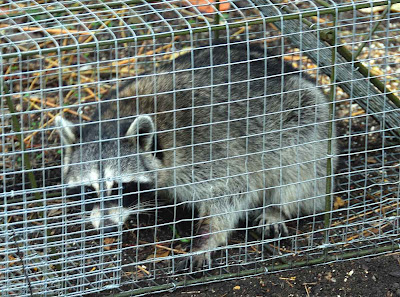
R is for Raccoon

R is also for:
Rascal,
Robber (Masked Bandit)
Relocated (read the story)
Resourceful


Big Raccoon
That's a big trap he's in. (Caught last night)

Don't worry.
He's OK


After I took his mug shot, I took him for a car ride and released him on probation. We live about 10 minutes from Fossil Creek which is a tributary of the Trinity River. Miles and miles of timber, creeks, and bottomlands for him to practice his trade.

I have been trying to trap him for about a week. They wander in and discover the cat food, chicken food, recycle compost, and water. "Looks like a good place to set up housekeeping", they say.

I think there may be another one. Martha and I heard a Raccoon Party on top of the house night-before-last. They really make a lot of noise screeching and chittering.


I guess I'll set the trap again tonight.
Leave a comment.

Have you ever had Raccoon troubles?

Troy and Martha

ABC Wednesday Round 3 is here.
.

Monday, November 17, 2008

My World Tuesday, Part 5

My World Texas,
Based in Ft. Worth, Texas

Today in Texas
End of the Season for Color

(Click on the photo for a full page view)

Caddo Lake in the Fall
Cypress Trees (Scanned slide)


The hardest part for photographing this shot, was waiting for the bass to quit jumping. It was probably a good day for fishermen but it was sure hard for still reflections. There was no sunlight, as the Sun was still hidden in the mist over the lake.

Caddo Lake (French: Lac Caddo) is a 25,400 acre (103 km²) lake and wetland located on the border between Texas and Louisiana, in northern Harrison County and southern Marion County in Texas and western Caddo Parish in Louisiana. The lake is named after the Southeastern culture of Native Americans called Caddo or Caddoans, who lived in the area from the 16th century until their expulsion in the 19th century. It is an Internationally protected wetland under the RAMSAR treaty and is the largest natural fresh water lake in the South, and the largest Cypress forest in the world. It used to be Texas' only natural lake until it was artificially dammed in the 1900s.

According to Caddo legend, the lake was formed by the 1811 New Madrid Earthquake. There may be some truth to the legend, as Reelfoot Lake in Tennessee was formed by that earthquake, but most geologists now feel that Caddo Lake was formed gradually rather than catastrophically. The lake was formed, either gradually or catastrophically, by the "Great Raft," a 100 mile (160 km) log jam on the Red River in Louisiana.


Since 1965 Texas' Caddo Lake has had hundreds of Bigfoot 'sightings' according to the Texas Big Foot Research Center (TBRC) as told on the Travel Channel 2006 Documentary "Bigfoot."


Leave a comment.
Thanks.

Troy and Martha


Please visit "That's my World" for other great places of the Earth.


.

Thursday, November 13, 2008

Oh, for Peace and Quiet

Sky Watch Friday

In Richland Hills, Texas, where we live, one of the water towers is less that 100 yards from our house. The good news is that we always have good water pressure in the summer, when everyone is watering the yard. One of the necessary evils is repainting it every 5-10 years. Now is the time. They are in the process of sand-blasting. Noisy and dirty. They start early and go late. It is LOUD! The wind is blowing toward us today and everything is coated with fine sand and paint dust. This photo was taken this morning.


It will look great when finished.
The blue had faded to light blue.

Photo - Martha's S51 Nikon


For other SWF posts,

see Tom's SkyWatch site here
.


Troy and Martha

.

Monday, November 10, 2008

Texas (Our Part of the world) #3

My World Tuesday Part#3
Texas,
Based in Ft. Worth, Texas

Today's Topic:
End of the Season for Insects
Butterflies, Skippers, Dragonflies, Damselflies

(Click on the photos for full page views)

It's just about the end of the season for insects here in Ft. Worth, Texas, USA. We will be having a hard freeze soon. Outside of town there have already been a couple of light frosts. The good news is that we can hook up the camper and go down to the Rio Grand Valley in extreme southern Texas during the winter. It almost never freezes down there and there are always a few hardy butterflies flying on warm days. It's also good birding in the Valley in the winter.

For your viewing pleasure
Here are some Fall insects from both here and the Valley.
I hope you enjoy them.
Photographs by Troy and Martha

Guava Skipper


American Rubyspot

Blue-ringed Dancer


Crimson Patch


Eastern Amberwing

Eastern Ringtail


Gulf Fritillary


Long-tailed Skipper

Lyside Sulphur


Phaon Crescent


Neon Skimmer

Sleepy Orange


Red-bordered Pixie


White-striped Longtail


We hope you have enjoyed a few of the insects from our small part of the world, and we look forward to your return. We sincerely hope you will bookmark us and return often.

What is your favorite Insect photo?
Leave a comment. Thanks.

Photography by
Troy and Martha


Please visit "That's my World" for other great places of the Earth.


.

Sunday, November 9, 2008

Akaska sunday XXX

.
Hiking Central Alaska
in July

You can see some beautiful sights in Alaska by Cruise Ship, Train, Air, or Car. But the real Alaska is best explored by foot. You don't have to take a 5 day back pack to experience this. Find a safe parking spot, get out your little day pack or fanny pack, take some water and a power bar, and find a trail (or not) and go. You don't have to walk far to experience the quiet and what it must have been like for the first explorers. If you are a birder, don't forget the binoculars and a lightweight field guide. You are going to see something new (guaranteed). Tree lines for 'song birds', scrub for sparrows, open hillsides for ptarmigan, lakes and pot holes for waterbirds.

Oh! Don't forget the camera with lots of film or big digital cards and the Alaska butterfly guide. You probably won't get close enough to the butterflies to photograph them.

The most obvious reason for hiking is that photo opportunities abound everywhere.
Today's post is three scenic photos taking while hiking Central Alaska.


Typical Central Alaska
South Central


Open Hillsides
North Central,
Higher Altitude


After 1AM
Don't get caught out too late!
Even though the sky may be bright after midnight,
the trails are hard to see
.


Don't forget to click on the Photos for full page views.
Leave a comment.
Have you been there and how did you travel?
Are you planning to go? Plan ahead!

Photos by Troy and Martha
.

Thursday, November 6, 2008

Going Out to Sea

Sky Watch Friday

Gray Clouds looking down on their Mother, the Ocean

We were at Texas Point, only a few hundred yards from the Gulf of Mexico, looking for Nelson's Sharp-tailed Sparrows, Seaside Sparrows, and Rails (you know ,the small thin bird, skinny as a rail). Texas Point is the most extreme point in SE Texas and composed mainly of salt marshes. We had left the 4-Runner and were walking quietly down the small gravel road which goes down to the radar station. We didn't have any cameras except for the little point and shoot that Martha always carries in her pocket.

The photo taken by Martha is of a tug, pulling a small drilling platform, which is going out to the off-shore waters. The channel is Sabine Pass which goes up to the shipyards and Port Arthur just beyond.

As always, Click on the Photos for full page views.


Going Out to Sea
Through the Salt Marshes
The high tide was going out, thereby helping the transport.
The water was still deep in the pass.
April 22, 2005, 6:22 PM (exif data)


PS: I looked up the Tide data on my Palm Smartphone,
Using "Tide Tool
" (Good for anywhere in the world, any date).


Topographic Map of Sabine Pass Area
(Centered on the small towns of Sabine and Sabine Pass)


Yes, we did see some Seaside Sparrows and Several Rails.
Leave us a comment if you liked the photo.

Do you like the inclusion of Topo Maps to show the location?


For other SWF posts,
see Tom's SkyWatch site here
.


Troy and Martha

.

Monday, November 3, 2008

Bridges Between

the North and South Rim
of the Grand Canyon


Navajo Bridge
Photo by Martha

(Click on the Photos for full page views)


Boats as seen from the Bridge
Photo by Troy


Completed in 1964, Glen Canyon Dam bridge is 1,560 ft (475.5 m)long and about 583 feet (178 m) above the Colorado River. Before it and the downstream Navajo Bridge (pictured here) were built, it was a 192-mile (309 km) drive to the other side of the canyon.

Troy and Martha

Be sure to leave a comment. Have you been there?
Have you been to the North or South Rim of the Grand Canyon?

Note: There had just been a slight shower, which had brought out the red in the rocks and soil. Good luck for me. Timing is everything. The only post processing was to adjust levels and a slight increase in saturation to compensate for the overcast sky.

A project by RuneE
Click here to participate.


.