Showing posts with label Alaska. Show all posts

Saturday, August 1, 2009

August Whale Calendar

.

It's August......

Have you made and printed your August Calendar yet?

Click on the photo and scroll to see all of the calendar


This was a fun photograph to make.

Rocking boat, moving pretty fast
Choppy waves...lots of vibration
Heavy overcast, shooting ISO 400
Anticipating the breach location

Nikon D200
18-200 mm Vibration Reduction Lens
1/640 sec, f/13, 200 mm focal length

After all the heat here in Texas, Alaska would be nice again.

Leave a comment and have a great August.

Troy

.

Thursday, March 12, 2009

Sky Watch Friday

.

We have been doing a lot of yard work and and home projects lately,
so no blogging for a couple of months.

I hope everyone is doing well.
I'll try to catch up on visiting everyone over the next couple of weeks.
It's raining here, so no outside work.

I thought I would share out March calendar (with a sky),
and a March moon (made with a point and shoot through the eyepiece of one of our telescopes).

Click on the photos and scroll for better full page views


Calendar of a Photo made on the Haul Road
Dalton Highway
414 mile gravel road

This is one of the really good sections


March Moon

Happy Sky Watch and have a good weekend.


For other SWF posts,
see the SkyWatch site here
.

Troy and Martha
.

Thursday, December 18, 2008

2009 Calendars

Sky Watch Friday

It's time to make your 2009 Calendars...
Sky Watch Photos would be a good theme...


Click on the photo and scroll up and down
to view the photo & calendar better


January


Size 13" x 19"
Printer - Epson 2200
Paper - Red River 68lb Ultrapro Satin 2.0
Camera - Photo Nikon D200


Are you going to make your own calendar?
What theme are you going to use?
Leave a comment and let us know what you think.


For other SWF posts,
see The SkyWatch site here.


Troy and Martha

.

Thursday, December 11, 2008

Clouds Resting

Sky Watch Friday

The clouds were resting on the mountaintops...

Alternate title:
'Exploring', But Not Over This Bridge!

We were 4-wheeling and exploring some old Alaskan mining roads high in the mountains when we encountered this old bridge missing most of its timbers. We were able to drive through the woods, ford the stream, and regain the road, hence bypassing the bridge. The stream was composed of glacier and snow melt and runoff from rain. It had been a steady drizzle all morning, and we weren't expecting nor concerned about flash floods. Also at this point, the valley walls were pretty steep, and it looked like the stream depth had never been more than a few feet deep.

Click on the photo to enlarge to full page width. You will have to scroll up and down to see the full photo. Most of the sky in this photo is resting on the ground and rushing down this icy cold stream. I was so anxious to get on up the road, I forgot to shoot to the left and right so that I could stitch together a panorama. Well, this was not the first time, nor would it be the last during this trip.

Clouds Resting

Where we forded the stream, it was about 40-50 feet wide and 18 inches deep. I put on my high top rubber boots and waded across checking for firmness of the stream bed and for holes. Then Martha drove across.

There were thousands of photos that we missed because we were so stunned by the view or the experience.
We are explorers at heart, naturalists by choice, and photographers when we remember to capture the moment.

Leave a comment and let us know if you like the view.


For other SWF posts,
see The SkyWatch site here.


PS: Martha is a lot better at capturing the moment, and reminding me to get the photo, than I am.
Troy and Martha


.

Sunday, November 9, 2008

Akaska sunday XXX

.
Hiking Central Alaska
in July

You can see some beautiful sights in Alaska by Cruise Ship, Train, Air, or Car. But the real Alaska is best explored by foot. You don't have to take a 5 day back pack to experience this. Find a safe parking spot, get out your little day pack or fanny pack, take some water and a power bar, and find a trail (or not) and go. You don't have to walk far to experience the quiet and what it must have been like for the first explorers. If you are a birder, don't forget the binoculars and a lightweight field guide. You are going to see something new (guaranteed). Tree lines for 'song birds', scrub for sparrows, open hillsides for ptarmigan, lakes and pot holes for waterbirds.

Oh! Don't forget the camera with lots of film or big digital cards and the Alaska butterfly guide. You probably won't get close enough to the butterflies to photograph them.

The most obvious reason for hiking is that photo opportunities abound everywhere.
Today's post is three scenic photos taking while hiking Central Alaska.


Typical Central Alaska
South Central


Open Hillsides
North Central,
Higher Altitude


After 1AM
Don't get caught out too late!
Even though the sky may be bright after midnight,
the trails are hard to see
.


Don't forget to click on the Photos for full page views.
Leave a comment.
Have you been there and how did you travel?
Are you planning to go? Plan ahead!

Photos by Troy and Martha
.

Thursday, October 30, 2008

Cook's Inlet

Sky Watch Friday


Beautiful Summer Day over Cook's Inlet
Anchorage, Alaska, USA
(Click the photo for a full page view)

The famous
Turnagain Arm of Cook Inlet is to the left in the photo.

Turnagain Arm is one of only about 60 bodies of water worldwide to exhibit a tidal bore. The bore may be more than six feet high and travel at 15 miles per hour on high spring tides. Turnagain Arm sees the largest tidal range in United States, with a mean of 30 feet (9.2 m), and the fourth highest in the world, behind Bay of Fundy (11.7m), Ungava Bay (9.75m), and Bristol Channel (9.6m). The ocean's natural 12-hour 25-minute tidal cycle is close to Turnagain Arm's natural resonance frequency, which then reinforces the tide similar to water sloshing in a bathtub. Tidal fluctuations in the main body of Cook Inlet, while not as extreme as the shallow and narrow Turnagain Arm, regularly reach 25 feet (7.6 m) and exhibit currents in excess of 5 knots (9.3 km/h) at full tidal flow. The inlet and its arms have been proposed as a potentially attractive site for the generation of tidal power.

We traveled back and forth along the arm over a dozen times and watched the tidal bore. sometimes the surfers come out and ride the one-time wave as it advances.

For more information on Cook's Inlet (click here).

If you like great 'wide-open spaces' Skies,
Scroll down one post to see some great sky photos from Big Bend National Park.
It will be worth your time.

Leave us a comment here and there.

For other SWF posts,
see Tom's SkyWatch site here
.


Troy and Martha

.

Sunday, October 26, 2008

Alaska Sunday XXIX

.
Uses for HDR Photography

All photos are from Alaska

(Remember to click on the photo for a full page view)

Many times when making a photograph, we shoot a photo +/- one stop (or more) to be sure we get a reasonably close approximation for the correct exposure. We then select the one that more closely approximates what the mind remembers, that which the eye saw. In a way, this is a type of manipulation of the photograph. A secondary software manipulation could be (a) sharpening a slightly out-of-focus photo, (b) adjusting the endpoints of white and black to produce purer whites and blacks (levels), (c) increasing the saturation on a cloudy day to increase the level of color intensity to a remembered level, (d) etc., etc.

Occasionally we make a photo of something that has a dynamic range of light to dark that the camera is not capable of capturing in one photo. The eye may be perfectly satisfied with what it saw and a picture is burned into the mind. We view the produced photo and say, "this is not what I saw or remember". Enter the fairly new software, HDR (high dynamic range) manipulation.

There are a lot pf web sites which discuss the use of HDR which was initially developed for the purpose of taking 3 or more exposures and combining them to produce one photo. i.e. expose for the sky, expose for the mid-tones, expose for the shadows.

For the intent of this demonstration, I am only concerned with taking a single frame photo (which may be unusable or just not what I expected or remember) and turning it into a photo which more closely approximates what I remember. It may not be perfect, but is acceptable for a photo album, a trip reminder, a special scene or occasion.

Please leave a comment and your thoughts. I am really interested.

Following are 4 examples of such photos.
What would you have done to the original?
Remember, the final or manipulated photo can't be compared to a photograph taken in good lighting conditions with a normal dynamic range and in most cases won't resemble one.


Fog
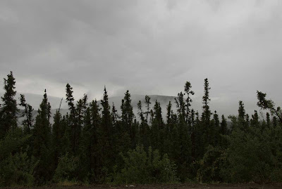

Original
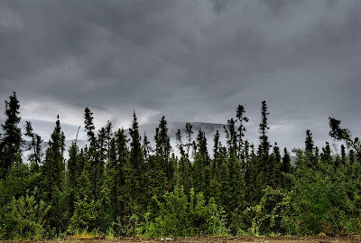
Corrected in order to
increase sky contrast and see detail in the foreground,


Misting Rain
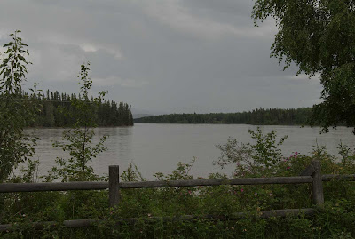
Original
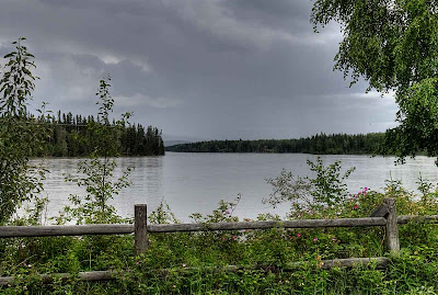
Corrected in order to increase contrast.
I did lose some of the effect of impending rain,
but gained color and detail in the fence row.
(I will probably go back and work on a compromise for this).


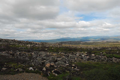
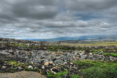
Finger Mountain Area
North of the Arctic circle


Original

Corrected in order to
decrease the dynamic range and
bring out the color and texture of these beautiful rocks


Clouds Rising
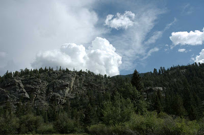

Original
(An acceptable photo to emphasize the sky)
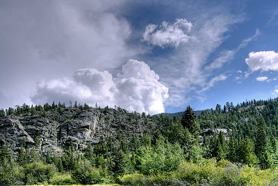

Corrected in order to
bring out detail and color in the foreground and cliffs.
It also shows the side lighting.


All of the photos are of scenes which had some special interest to us,
rather than just capturing a nice photograph


Photos by Troy and Martha
HDR Processing by Troy
Final exposure negotiated between Troy and Martha

.


Sunday, October 19, 2008

Alaska Sunday XXVIII

Four-wheel Drive Day

Hope, Alaska
July 17

While we were using Anchorage as a base camp, we decided one day to drive around to Hope, AK for a day of birding and photography. Hope is situated on the southern side of Turnagain Arm off of the Cook Inlet. It is about a 2-3 hour drive to Hope from Anchorage. It is a beautiful drive through the Chugach National Forest on the West side of the Chugach Mountains. Lots of wildlife, from Squirrels to Moose to Thin-horn Sheep.

We had read of a great 4-wheel drive road South out of Hope up Palmer Creek Road and Resurrection Creek Road. We spent a couple of hours on the Palmer Creek road and then returned to Hope for lunch at a little Mom and Pop Diner. Great food.

We then returned to the Resurrection Creek Road and started up the valley. Up near the treeline we hoped to find some Golden-crowned Sparrows. We found beautiful meadows lush with wildflowers, grasses, and amazing vegetation. Eventually we encountered a sign "4-Wheel Drive Only." Of course, we proceeded on around the sign. The next sign said something like "Turn Around Here, Road Impassable". Of course we drove around it and proceeded. Much of the road was overgrown with small brush, and we did get some scratches in the Clear coat and Paint (about 8 hours work with the buffer, scratch remover, and polish when we got back to Texas). We saw some beautiful scenery and best of all, we found the summer breeding ground of the Golden-crowned Sparrow. In all of our years, we had only seen one other Golden-crowned Sparrow migrating through West Texas.

Following are a few photos along the way.

Be sure to click on the photos for a full page view.


Lower altitude Meadow


Higher altitude


Cold (really cold) Mountain Stream
It felt colder than the Arctic Ocean that we waded in


Mountain Valley
Still lots of snow up here


Getting near Resurrection Pass


Most of the photos have been adjusted with Photomatrix Pro 3.1 beta 9. The dynamic range of the photos at the high altitudes is beyond the ability of the camera to capture and show detail in the blacks and shadows without completely washing out the sky and bright areas. This is especially true when shooting into the sun.

Important to us!
Please leave a comment and let us know which is your favorite.


Photos by Troy and Martha. I don't remember who made which Photo.
We were both shooting the D70 and D200 interchangeably.

Troy and Martha

.

Sunday, October 5, 2008

Alaska Sunday XXV

.

Homer Alaska

A short break from the trip log. I have not had time to post lately due to prior commitments, and have not had time to compile milages and locations.

Here are a few photos from the stay at Homer, AK. They have a great RV Park on the spit which juts out into the bay. Before we drove down here to stay a few days, I had checked the tide tables to make sure we would have some exposed tidal flats for exploration. It worked out great. The only problem was the wind while we were there. It was fierce. The trailer jumped up and down all night. As typical, on the day that we left, the wind calmed and the sun came out. Oh well, we had a great time anyway.

Be sure to click on the photos for a better look, especially the Starfish


Entering Homer
Great,great,great food here.


The Spit
That's a town at the end and several RV Parks (expensive)


We are in the second row
The first row was $20.00 more per night. I used the extra $60 I saved,
to help with the purchase of a nice Inuit Basket


Tidal Flat exposed
The bottom was firm gravel and rocks,
so we could walk all the way to the drop-off.


Martha found a nice Starfish
Zillions of Mussels, Crabs, Starfish, etc.
Our backs were really tired from the bending over.


Notice Martha's red hands from fishing around in that really frigid water.


Comments appreciated.
Have you been here before? Are you planning to go?

Troy and Martha
.

Sunday, September 28, 2008

Alaska Sunday XXIV

.

Last Sunday on the trip log we had arrived back in Anchorage.
Instead of the Trip Log today, I have a photo which I just ran across while still sorting the 18,000 photos that we saved on DVD's. I am archiving and sorting them on 2 separate external Hard Drives.

I did not realize that I had this photo until this morning. In last Sundays post I concluded with a sunset shot to the East showing the red glow on the mountains. I turned around and shot a photo of the RV Park towards the West. This photo is the result of "just a snapshot". It was after 1 AM, had been a long day on the road, and I was too tired to pay attention to what I was seeing.

Sundog in Anchorage
As photographed
(Click to view larger)

Have you ever photographed a sundog or halo?
Leave a comment.

Troy and Martha

Sunday, September 21, 2008

Alaska Sunday XXIII

Trip Log - Part VI
July 3 - July 6

The sixth installment of the actual trip log and mileage of 'The Drive from Texas to Alaska and Back'.

As mentioned previously, this log does not contain too much commentary. It is mainly sequential locations, dates, mileage traveled, photographs showing the trip progress, and how the landscape changed. The Alaska Trip Log is divided into short intervals (parts) and I am posting it on consecutive Sundays. Past and future posts of Alaska Sunday (apart from the trip log) will have more detailed information, and more photos of each specific area.

Click on the links for more photographs and detailed descriptions of this part of the trip.

Last week was a temp post. Today we will continue with mileage from Fairbanks to Denali and on to Anchorage.

Be sure to click on the photographs for full screen views.

And so, on with the trip.


7/3 Fairbanks, Alaska to Denali, AK 156 mi


7/4 Denali and Healy area 65 miles


Red Squirrel - Western type


Snowshoe Hare
Summer coat (He still has white feet)


Winter food for the Animals
Lots of mosses and lichens in the shelter of the trees

7/5 Denali Highway and back to camp 220 miles

We did not drive all of the Denali Highway. Too many stops.
It was mostly cloudy all day. We did get one break in the clouds to photograph the following panorama even though most of the landscape was in shadows.

Alaska Range Panorama
From the Denali highway looking NW

7/5 Denali RV Park to Anchorage 210 miles

Sunset after camp was set up
about 1 AM


Next week we will be around the Anchorage area.

Mileage for this section of the log ...........651 mi
Mileage before 7/3 ................................8944 mi

Total miles for the trip to date ...............9595 mi

We are closing in on 10,000 miles


Comments are appreciated.
Let me know if you are keeping up with the trip,
or are just a onetime visitor.

Troy and Martha

Thursday, September 18, 2008

Above Valdez

Sky Watch Friday

Valdez is the southern terminus of the oil pipeline crossing Alaska from the North Slope Oilfields.

There is a small hard-to-find slate/gravel road on the Northwest side of town. It goes for miles and miles, climbing higher and higher towards the glaciers. You have to ford a river on the way since the bridges are long gone.

Looking back and down towards Valdez
Click on the photo for a better feel

It was a great day to climb through the clouds. I wish I could describe the fresh air and all of the smells associated with this drive to the sky.

For other SWF posts,
see Tom's new SkyWatch site here
.

Troy and Martha

Sunday, September 14, 2008

Alaska Sunday XXII

.


For the new visitor, check out the early posts on the Small Boat Cruise out of Seward.

Part I

Part II

For those that have been following the Alaska adventure and for your temporary Alaska fix, here is one unpublished photo.

Denali


Troy and Martha

Sunday, September 7, 2008

Alaska Sunday XXI

Trip Log - Part V

June 26 - July 3

The fifth installment of the actual trip log of 'The Drive from Texas to Alaska and Back'.

As mentioned previously, this log does not contain too much commentary. It is mainly sequential locations, dates, mileage traveled, photographs showing the trip progress, and how the landscape changed. The Alaska Trip Log is divided into one to two week intervals (parts) and I am posting it on consecutive Sundays. Past and future posts of Alaska Sunday (apart from the trip log) will have more detailed information, and more photos of each specific area. Most of the photographs in this log section were previously posted when describing specific locations.

Click on the links for more photographs and detailed descriptions of this part of the trip.


Last week we arrived in Fairbanks. Today we will continue with mileage to Coldfoot, Deadhorse, and back to Fairbanks.

Be sure to click on the photographs for full screen views.

And so, on with the trip.


6/26 Fairbanks, Alaska to Coldfoot, AK 261 mi


Martha under the Pipeline


A lot of gravel road to go


Standing on the Arctic Circle looking NW
Just after the Summer Soltice


See AK Sunday V, click here.


Slate Creek Inn at Deadhorse
$149.oo per night for a box room


See AK Sunday VI, click here.


Martha caught me resting


Koyukuk River at Midnight
Photography after a little rest


See AK Sunday VII, click here.


6/27 Coldfoot, AK to Deadhorse, Ak 247 mi


Cirque in Atigun Pass
Brooks Range


Looking Back at the Brooks Range
Alaska Pipeline

See AK Sunday VIII, click here.


6/28 and 6/29 Around Deadhorse and Prudhoe Bay, AK 120 mi


Chasing butterflies (one in the net)
Near the Arctic Ocean


6/30 Deadhorse back to Coldfoot 240 mi


Racing ahead of a flash flood
Koyukuk River
In 1994 floods on the river swept away three villages,
forcing the wholesale relocation of the population.


See AK Sunday XI, click here, for more of this exciting part of the trip.


7/1 Coldfoot back to Fairbanks 245 mi

7/2 Fairbanks area 22 mi

Next week we will travel to Denali National Park with lots of Photos in that area.

Mileage for this section of the log ...........1135 mi
Mileage before 6/26 ................................7809 mi

Total miles for the trip to date ...............8944 mi


Comments are appreciated.
Let me know if you are keeping up with the trip,
or are just a onetime visitor.

Troy and Martha

Thursday, September 4, 2008

Denali N.P. - Big Sky

Sky Watch Friday

Have you ever been in a place where the sky just looked 'bigger' than normal. This was one such place. A glaciated valley in Denali National Park in Alaska, USA. This looks better enlarged, but still doesn't feel like being there.


Big Sky - Denali N.P.

Sky larger than life

Leaves a lasting impression
Smell the fresh clean air


For the Geologist - Notice the directional side valleys and rounded shape of the main valley. It's a couple of miles over to the far side.

For the Naturalist - Notice the Golden Grizzly on the far slopes (a mile or more away). We saw the bear in the spotting scope, but now I can't find him in the photo. You will just have to use your imagination.

I have only been a few places where I remember the sky looking larger than life. Montana and West Texas to name a couple.

It's curious, but out on the Ocean, the sky doesn't seem large. I guess it's because the Ocean seems so large.

Where have you experienced the sky seeming larger than life?

Leave a comment, inquiring minds want to know.

Photo by either Troy or Martha

Troy and Martha


For other SWF posts,
see Tom's new SkyWatch site here.
.